Maximum temperatures were markedly above normal(5.1°C or more) at most places over Uttarakhand, West Uttar Pradesh and Jharkhand; at many places over Punjab, East Madhya Pradesh and East Uttar Pradesh; at a few places over Haryana, Chandigarh & Delhi, Himachal Pradesh, Bihar, Gangetic West Bengal and Odisha; at isolated places over East Rajasthan and West Madhya Pradesh; appreciably above normal (3.1°C to 5.0°C) at many places over Nagaland, Manipur, Mizoram & Tripura, Chhattisgarh and West Rajasthan; at a few places over Gujarat, Madhya Maharashtra, Konkan & Goa and Telangana and at isolated places over Jammu & Kashmir, Ladakh, Gilgit-Baltistan & Muzaffarabad and Vidarbha; above normal (1.6°C to 3.0°C) at many places over Marathawada and Rayalaseema; at a few places over Coastal Andhra Pradesh & Yanam and Tamilnadu, Puducherry &Karaikal; at isolated places over Kerala &Mahe and Karnataka. Yesterday, the highest maximum temperature of 40.0°C was reported at Bhubaneshwar (Odisha) over the country(Annexure 1 & 2).
Temperatures Recorded at 1430 Hours IST of Today, the 1st March, 2021
o Akola (Vidarbha) recorded the highest temperature of 38.9°C (Annexure 3).
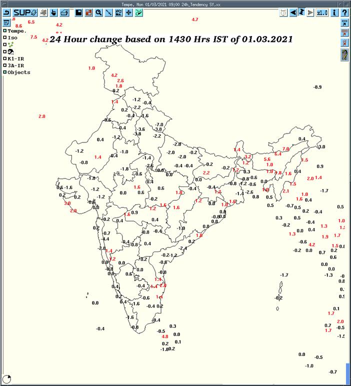
o Temperatures recorded at 1430 hours IST of today have risen by 1-2°C at many places overSub-Himalayan West Bengal & Sikkim and Assam & Meghalaya; at a few places over Jammu & Kashmir and at isolated places over Punjab, West Rajasthan, Saurashtra & Kutch, Madhya Pradesh, Bihar, Jharkhand, Vidarbha, Tamilnadu and Odisha (Annexure 4).
Heat Wave Warnings for Next 5 Days (on next page)
o Maximum temperatures are currently 3-6°C above normal over north & central parts of India includes East Rajasthan, Haryana, Chandigarh & Delhi, Uttar Pradesh, east Vidarbha, Madhya Pradesh, Chhattisgarh, Odisha, Bihar, Jharkhand and Gangetic West Bengal.
o It is likely to fall by 1-2°C over Northwest & adjoining Central India during next 2 days (01st-03rd March). No significant change in maximum temperatures over rest parts of the country.
(For significance of colour code, criteria and its Impact & action suggested for Heat Wave kindly refer to Annexure-5 at end of this document)
Heat Wave
Heat wave is considered if maximum temperature of a station reaches at least 40°C or more for Plains, 37°C or more for coastal stations and at least 30°C or more for Hilly regions. Following criteria are used to declare heat wave:
a) Based on Departure from Normal
o Heat Wave: Departure from normal is 4.5°C to 6.4°C
o Severe Heat Wave: Departure from normal is >6.4°C
b) Based on Actual Maximum Temperature (for plains only)
o Heat Wave: When actual maximum temperature ≥ 45°C
o Severe Heat Wave: When actual maximum temperature ≥47°C
To declare heat wave, the above criteria should be met at least in 2 stations in a Meteorological sub-division for at least two consecutive days and it will be declared on the second day.


